Showing posts with label london. Show all posts

Monday, 12 August 2013

The road not taken

I recently changed the route of my cycle commute into central London, trading a longer journey (about five minutes more) for a cleaner, safer and less stressful one. The downside is it takes me half a mile and about five minutes more to get to work, but by going over Southwark instead of London Bridge the upside is I'm less likely to be crushed by a truck or get respiratory problems from the air around Bank.

Cyclists make these kinds of calculation all the time. They take quiet back streets to avoid dangerous main roads, they dismount and cross at pedestrian signals rather than try to turn right across moving traffic, and so on. There are a number of daredevils who take the most direct route to where they're going regardless of the conditions, but in my experience almost everyone who cycles accepts some kind of delay or diversion in exchange for extra safety, comfort or peace of mind.

But that's just the people who cycle, and in Britain they are relatively few in number. Most people don't cycle, presumably because they don't think it worth their while. On the face of it this is a puzzle, since cycling can be faster than driving or other modes of transport in many contexts. But the reality is that this speed advantage can be wiped out if you have to make too many of these delays and diversions to make the trip acceptable by bike. If people have to go around the houses to feel safe on a bike, many of them will just take the car instead.

The flip-side is that if we can make the quick and direct routes safe and comfortable to cycle, then many people will find that cycling suddenly makese sense for them. This is what happens in the Netherlands, where people are not expected to either brave unpleasant conditions on main roads or work out a convoluted but quiet route on back roads. By making cycling safer, they have made it quicker too, and that's the key.

Evidence on how far people will go out of their way to avoid unpleasant or dangerous roads has long been one of the missing pieces in understanding the choice of whether or not to cycle. If we knew how much time people would give up to avoid a bad junction, we can guess how much time we could save them by making it safe and pleasant to cycle through, and then estimate the impact on cycling's local mode share, traffic congestion and so on. These factors are key to the kind of economic analysis which determines how transport funding gets spent and which has so far more or less ignored cycling.

So this research into cyclists' route choices carried out for TfL by Steer Davies Gleave could be very important, because it tries to answer exactly these questions. They asked people (mostly people who cycle in London) to rate the attractiveness of different types of junction types and cycling conditions, and crucially it asks them how much time they would be willing to add to their journey to avoid particular situations.

Here are some of the results. First, the extent to which people agreed with various statements about route choice, by their frequency of cycling, age and gender.


The first thing to note is how many people, even frequent cyclists, agree with statements like "If I had to negotiate a number of difficult junctions I would try to find another route" and "I would prefer cycling in a cycle lane which is separate from the traffic even if it meant a longer journey". But the different average responses by gender are striking too: women seem significantly more likely to change their routes due to safety concerns than men, consistent with findings from the British Social Attitudes survey showing women are more likely to think the roads are too dangerous to cycle. Finally, long-term cyclists (those with more than two years experience) are consistently more willing to endure bad conditions in exchange for a quicker journey than inexperienced ones. There is probably a learning or hardening effect here, with people becoming more skilled or better able to cope with unpleasant conditions over time - but there is undoubtedly a selection effect too, with many people trying out cycling but not keeping it up due to safety issues. Experienced cyclists constitute the small minority of people who are willing and able to deal with the problems posed by cycling on British roads.

The researchers also asked people to rate how safe they felt cycling through different types of junctions.


Here, the striking thing is how unsafe people (mostly cyclists, bear in mind) think fairly common junction types are. The very first junction in my five-mile commute to work is a right turn from a side road onto a main road, and it's not very nice: I have to wait for a suitable gap in the streams of traffic and then dart into it at a decent speed. Clearly for many people this would be one junction too far and the journey as a whole would be unviable by bike.

The next charts illustrate how important this all is.


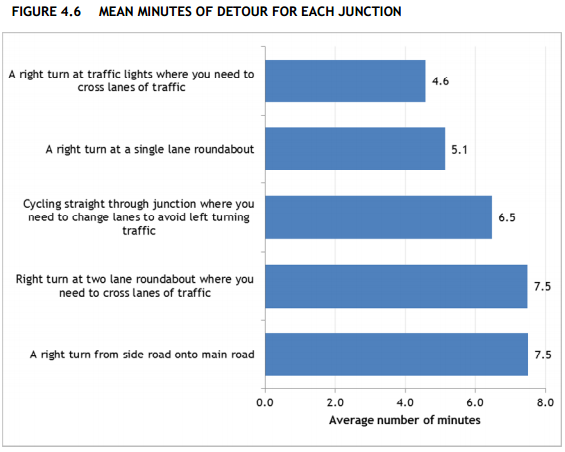
A majority of people said they were willing to accept a detour of over five minutes to avoid a right turn at a two-lane roundabout, or a right turn from a side road to a main road. The average was 7.5 minutes. These are very big figures, surprisingly big to me at first - but I'm an experienced, battle hardened cyclist, and as I said at the start I still make detours, though maybe not as big.

It's worth emphasising again that these kinds of results go a long way towards explaining why more people don't cycle in Britain. It's because our main roads are so dangerous and unpleasant to cycle on that people would rather sacrifice huge chunks of time than do so, to the extent that cycling is for most purposes no longer worthwhile.

Finally, the researchers asked people to compare different types of cycling facility. The chart below shows the average benefits people ascribed to each type of facility, with the most popular (off-road routes) set at 100.


The key result here is that there is a big preference for off-road cycling infrastructure as compared to bus lanes, advisory cycle lanes or mandatory cycle lanes, particularly among women. In comparison, the type of road doesn't seem to matter very much.

This certainly looks like a big win for segregated bike lanes (consistent with lots of other evidence on the subject), but it's worth bearing in mind that the picture of an 'off-road' route people were prompted with (below) looks more like a route through a park than a typical segregated track alongside a main road, and that has probably affected the results somewhat.

This is very valuable research because it starts to quantify the extent to which our current road designs fail people and prevent cycling from becoming a mainstream choice, and because it can also help us quantify the benefits of better infrastructure. It deserves to be read widely, by both campaigners and planners.

Monday, 29 July 2013

Quantifying the costs of road casualties in London, by borough and mode of transport

Injuries and deaths as a result of road collisions impose huge costs on our society, both on the people directly involved and an others more indirectly affected. While everyone will react differently to being in a road collision, we can try to quantify the average social and economic impacts in order to get at the overall cost to society as a whole and hopefully provide a further incentive for change.

The Department for Transport estimates the total cost of a road fatality to be around £1.7 million, of a serious casualty around £190,000, and of a slight casualty around £15,000. These are arrived at using the 'willingness to pay' economic method, and are meant to take into account the 'human costs' of suffering and grief, lost economic output due to injury or death and the costs of medical treatment.

Using these figures DfT estimates the total cost of reported road casualties in Britain in 2001 to be around £15.6 billion, and the total cost including unreported casualties to be up to around £34.8 billion.

Using the same average costs, Transport for London estimates the total cost of reported road casualties in London in 2011 to be around £2.35 billion. Since TfL also provide data on the location, mode and severity of each casualty in London in 2012, we can use the same figures to see how these costs vary from borough to borough and mode to mode.

The chart below shows the estimated total social and economic cost of reported road casualties in 2012 by borough and the casualty's mode of transport, using DfT's averages. There's a table with the same figures below the fold.


There are huge variations between boroughs in terms of both the scale and the composition of the costs associated with road casualties. The total cost in lowest in Kingston at around £27 million, and highest in Westminster at around £128 million. In Outer London boroughs car occupants account for a higher proportion of casualties and therefore of costs, while in some Inner London boroughs pedestrians and cyclists account for over half the costs, reaching 58% of the total in Westminster and 69% in the City of London. Across all boroughs the total costs by mode come to £523m for pedestrians, £345m for cyclists, £674m for car occupants and £518m for other modes (motorcycles, buses, taxis, goods vehicles, etc).

It's worth emphasising that these figures are bound to be an underestimate. Not only do they cover only reported casualties and excluse those that go unreported, but they arguably don't capture the full range of costs. Road danger results in 'avertive' behaviour, where people go out of their way to avoid particular danger-spots or choose to take modes of transport which are safer but slower or more expensive. These costs are very difficult to quantify and so they aren't included in the DfT figures.

Also, the average costs per casualty are likely to be higher in London than in other parts of the country, given the higher wages in London and therefore higher costs of lost output and higher 'willingness to pay' to avoid casualties.

It may sound callous to talk about road casualties in terms of money but this is really just a way to try and quantify the non-monetary costs in a rigorous way. And I think these figures could be a useful tool for campaigners too. Some boroughs don't seem to attach enough importance to road safety (or road danger reduction, if you prefer), but if the government were to levy fines on them in proportion to these costs I think it would concentrate minds pretty rapidly.

Monday, 1 July 2013

Trends in London cycling casualties

Last Friday Transport for London released statistics on London's recorded road casualties in 2012, along with (for the first time) some useful raw data - see under 'Data extracts' here. I've used the new figures to update some long-term trends in cycling casualties in London. Unfortunately they don't make for cheerful reading.

The first chart shows the trend in total recorded cycling casualties, split into slightly injured and killed or seriously injured ('KSI', in the rather inadequate jargon). As you can see, total casualties peaked in the early and late 1980s, fell fairly steadily in the early years of this century but rose again from about 2007, reaching just over 4,600 in 2012.


The large number of slight casualties hides the trend in fatl or serious casualties so the next chart isolates those. It show a slightly different trend, peaking in 1989 at almost 800 a year and with a sharp increase in the last few years to 671 in 2012.


These trends are pretty grim for cyclists, which as the chart below shows have comprised a seemingly ever-increasing share of London's fatal or serious road casualties over the last decade, reaching a fairly shocking 22% in 2012. Maybe instead of asking that cyclists get a share of investment equal to their mode share (around 2%) we should be demanding they get the same as their share of casualties?


Finally, let's have a look at cycling in the City of London, the tiny square mile at the heart of London which so many of us have to cycle through even if the people who run the place would rather we didn't. The first chart here shows a rising trend in total cycling casualties in the City since 1986.


And the second chart shows the trend in fatal or serious cycling casualties.


It should be fairly clear that the City has a big problem with cycling safety. Bear in mind that its Local Implementation Plan sets a target to reduce the number of fatal or serious casualties (of any type) to a yearly average of 39 by 2013 (4.54 here). But instead the trend is going in the opposite direction, with 49 killed or seriously injured in 2011 and 58 in 2012. As the chart above shows, cycling accounts for much of this increase, so maybe the City needs to radically change its approach to cycling provision if it's to have any chance of meeting its own targets.

One of the questions people reasonably ask when they see these kind of trends is whether casualties are rising faster than the number of people cycling, which we know has grown a lot in recent years. TfL point out that cycling on London's main road network has increased by 60% since 2005/06, but that overstates the growth in cycling trips around London as a whole, which as of 2011 had increased by only around 16% over the 2005-09 average compared to a 36% increase in fatal or serious casualties (compare table 3.5 here and table 2 here). So it's safe to say that the cycling casualty rate has worsened over the last few years, even if it's better than it was in the 1980s.

Tuesday, 21 May 2013

Road crashes and smoothing the flow

As this slide from a 2012 TfL survey shows, drivers on London's main roads are much more likely to report delays due to roadworks than due to road accidents ('collisions', more accurately) - but TfL's own data shows that in reality collisions are a much more significant source of delay.
And while delays due to roadworks have fallen, presumably due to a flurry of TfL measures designed to reduce the number and length of works on main roads, delays due to collisions remain stubbornly high and are now more than twice as large as for roadworks. 

So just as Andrew Gilligan has been selling his cycling strategy as a way to reduce congestion, shouldn't we also be seeing a big push to drastically reduce the number of road crashes as a way to 'smooth the flow'?

Sunday, 12 May 2013

History and cycling's mode share in Amsterdam and London

This presentation by RenĂ© Meijer of the City of Amsterdam has a useful chart showing the transport mode split in Amsterdam by the length of the journey.

I've tried to recreate it for London, using data from the London Travel Demand Survey downloaded from TfL's Romulus website*. It's not possible to make an exact comparison, for a few reasons:
  • For London I use data on journey 'stages', which includes things like walking to the bus stop. It's not clear whether the Amsterdam data uses data on stages or on the main mode used for a trip from A to B.
  • The journey distance categories are slightly different between the two cities.
  • I've included motorcycle journeys in the 'car' category in London, but it's not clear whether or how they are counted in Amsterdam.
With those caveats in mind, here's the London chart.
Note, I've tried to use similar colours, so the reason there's lots of red in the Amsterdam chart and hardly any in the London chart is that lots of people cycle in Amsterdam and hardly anyone cycles in London. The difference is huge, and seems to be made up by a mix of more travel by car and by public transport in London for trips of between 0.5 and 10 km.

London's high public transport share for medium-length trips (predominantly bus until for trips of up to 6km and predominantly Underground/DLR thereafter) is striking, and I think a little under-discussed in the debate about growing cycling. We have a pretty wonderful public transport network that competes against cycling both in terms of attracting passengers and, in the case of buses, for road space. Even though there is definitely scope for huge growth in cycling with the right policies in place, this starting point probably means we're unlikely to match Amsterdam's modal share even for trips of the same length. Cities can't choose their history, and that can make a huge difference to their future.

* You'll need to request a password to access the full site.

Friday, 22 March 2013

Cycling fatality rate about five times as high in London as in Berlin

The other day Danny from Cyclists in the City linked to the city of Berlin's new plan for improving cycling conditions. I haven't been to Berlin for years and don't know what it's like to cycle there, but on the face of it the strategy looks pretty good.

What the strategy documents also allow us to do is compare how dangerous cycling in Berlin is to cycling in London, using the fatality rate per kilometre cycled. Berlin's strategy says (in German) there are 1.5 million cycling trips  a day, at an average of 3.7 km a trip, giving a total of just over 2 billion km cycled per year. And in the last three years there were 26 recorded cycling fatalities or 8.7 per year, giving an annual rate of 0.43 fatalities every 100 million km (or to put it the other way, over 230 million km cycled for each one fatality).

We can get comparable figures for London from the annual Travel in London report and road casualties reports. According to the data on trips per day (table 3.5) and average distance per trip (figure 2.5) in the most recent Travel in London report, there were 0.5 million cycling trips a day in London over the last three years, at an average distance of 3.1 km per day, giving a total of 553 million km cycled per year in London. There were also 39 cyclist fatalities in this period or an average of 13 per year, giving an annual rate of 2.35 fatalities every 100 million km (or just over 40 million km cycled for each fatality).

So it looks like the fatality rate for cycling in London is about five times as high as in Berlin. Note, these figures shouldn't be subject to the same concerns over casualty recording as the serious injury rates I calculated before, as fatalities are much less subject to under-recording than injuries.

Here's a table with all the numbers:

LondonBerlin
2009201020112009-112008-10
Trips per day (millions)0.470.490.500.491.50
Distance per trip (km)2.993.313.043.113.70
Total distance per year (m km)5125915555532,026
Fatalities in period1310163926
Fatalities per year131016138.7
Annual fatalities per 100m km2.541.692.882.350.43
Million km per fatality39593543234

Monday, 4 March 2013

Mapping cyclist casualty concentrations in London

I've produced some maps of London cycling casualties on this blog before but it's hard to come up with an image that manages to capture both the scale and the spatial specificity of the issue. It matters where cycling casualties happen and it also matters how many there are in a particular area, but at the London-wide level there are so many that the most straightforward visualisation techniques just aren't adequate, even before you start trying to understand the underlying patterns of exposure and causation.

Here, for example, is a simple map showing one dot for every recorded cycling casualty in London over the five years to 2011 (the most recent year available). It includes fatal, serious and slight casualties, with the latter category by far the largest.
This map does tell us some useful things: cycling casualties are heavily concentrated in central London, and judging by the linear patterns seem to be common on major roads too. But there are so many casualties in the centre that the image becomes overwhelmed and you lose a sense of either scale or space. Some kind of aggregation would help.

Following the steps outlined on the Mapbox blog here, I generated a 'heatmap' of cycling casualties in Quantum GIS. A heatmap is a technique that uses spatial interpolation to predict the number of events (in this case, cycling casualties) in a small part of an area based on the actual number observed in or close to that area. It smooths out the pattern a bit and highlights with variations of colour the locations with the greatest concentrations.

If anything, this shows even more clearly how many casualties there are on London's major roads (including many of the ancient Roman routes shown recently on the Mapping London blog). I thought it could do with a bit more clarity, so, again following the Mapbox tutorial, I added some definition using contour lines, and a legend.  Note that the heatmap model 'predicts' 140 casualties in the deepest red cells and zero in the deep blue squares that cover most of the suburbs.


Maybe the contours look a bit messy at the London-wide scale but when you zoom into the city centre I think they help, partly by overcoming the blockiness of the heatmap results. In the map below I've labelled the areas in central London with the greatest concentrations of cycling casualties in the last five years. As you can see, the Elephant and Castle area is pretty clearly the worst in terms of the number of casualties, while there is a cluster of areas just north of the river also focused on major junctions.


Finally, here's a version with the street network showing underneath.

Tuesday, 19 February 2013

Animating London's population change 1801-2011

Over the last couple of hundred years London's population has grown and spread out on a vast scale. This process has involved a remarkable deconcentration of population from the centre to the suburbs: in 1801 the vast majority of its million people were crammed into a few central boroughs, with the square mile of the City of London holding 129,000 people. The population of the city grew by more than 5 million over the next century with the vast majority of that growth in the inner suburbs opened up by public transport. Over the course of the 20th century suburbanisation accelerated with the advent of the car, only for population growth to pick up again in the centre in the last few decades.

Summing up all this change in a single graphic is quite a challenge, so instead I've made this simple animated map, illustrating the changes in population using a dot-density approach where every dot represents 2,000 people. The dots are randomly distributed at borough level at the point of each Census starting in 1801 and ending in 2011, so they are not meant to represent the exact locations of individual settlements.


The maps were made in R using data from the Census (downloaded from the London Datastore and updated with 2011 data) and boundaries from the Ordnance Survey. The animation was done in UnFREEz as I couldn't get the native animation in R to work.

Sunday, 17 February 2013

What the congestion charge did

The London congestion charge was ten years old this week, which provoked a bit of discussion about it, most notable for the absence of anyone seriously calling for it to be abolished. As Adam Bienkov points out, its introduction in 2003 was by contrast preceded by an avalanche of criticism and predictions of doom, much of it motivated more by political grievance than by evidence or principle.

I think the best way to get a sense of the C-charge's impact is to look at Transport for London's data (here, under 'Central London Peak Count') showing how people travelled into central London during the weekday morning rush-hour between 1978 and 2011. The chart below shows the trend for people arriving by car or motorcycle only (for some reason TfL don't separate the two out).

The number of people entering central London by car (and motorbike) has clearly been trending downwards since the early 1980s, but just as clearly there was a very big drop in the early 2000s. What's really interesting is that although there was a big dros (of about 20,000) in 2003, the first year of the C-charge, that was preceded by two years of almost equally big drops in 2001 and 2002. I don't know very much about what transport policy was like back then but given that the same TfL data shows a concurrent spike upwards in bus ridership it does look rather like a generalised 'Livingstone effect' rather than something limited to the congestion charge alone, though obviously that was a very important part of it.

More recently the decline in car traffic has slowed a bit and in 2011 there was even a small increase, though hardly a noteworthy one. And if anyone is dissatisfied with current congestion levels in London, as for example the AA seem to be, the obvious answer is to campaign vigorously for an increase in the charge.

Sunday, 10 February 2013

A couple of maps showing where in London cycling commuting did and didn't grow between 2001 and 2011

A couple of weeks ago I posted a map showing the mix of commuting modes by ward in London from the 2011 Census, and this week I'd like to focus on the change in cycling levels since 2001. The maps below (click here and here for PDF versions) show the change in cycling, again at ward level, first the change in the number of people cycling to work in each ward and then the change in cycling's share of all commuting. I've included both because the numerical increase is interesting but can be distorted by differences in population growth.


In both maps the yellow areas represent areas of decline, the greens no change or moderate growth, and the blues higher rates of growth.

Growth in cycling commuting is concentrated in inner London and the South West, with the greatest increase in both proportional and absolute terms in Hackney. A couple of other patterns jump out: the rich boroughs of Westminster and Kensington and Chelsea are exceptions to the inner London rule, showing very little growth in cycling over the last decade, probably due to a combination of car-friendly policies and demographic factors. Newham also stands out as showing very little growth, suggesting that the river Lee or rather its crossings may be quite a significant barrier, hopefully something the new superhighway will address. South of the river there look to be pockets of high growth, in numerical terms at least, along the routes of Cycle Superhighways 7 and 8 and in a few other areas.

But while most of inner London saw pretty good growth in cycling over the decade, Hackney is clearly the star of the show. In 2001 4,940 people in Hackney said they cycled to work. By 2011 that had more than trebled to 17,312. Hackney's workforce grew at the same time, but there was a big increase in cycling's commuting mode share too, from 6.8% in 2001 to 15.4% in 2011 (in both cases excluding those working from home). In five wards cycling's mode share grew by more than ten percentage points. As Cyclists in the City pointed out, more people commute by bike in Hackney than by car or van.

There's an interesting debate to be had about whether the Hackney trend is due to demographics (an influx of young carless people), the emergence of a fairly localised pro-cycling sub-culture, or Hackney council's approach to road safety. Danny says here it's about policies and I've no doubt they're an important factor, but in my admittedly partial experience cycling in Hackney is no better than in Islington so I suspect demographics and culture have played a role too. We may know a bit more when more detailed Census data on who is cycling where comes out later in the year.

Saturday, 9 February 2013

Dangerous driving and London's draft policing plan

The Mayor's Office for Policing and Crime (MOPAC) are currently consulting on a draft Police and Crime plan for London, to cover the period 2013-17. You can read the draft here and there's a short survey about it here. The London Assembly are carrying out a review into the draft plan too, which you can read about here. The MOPAC consultation runs until 6 March while you have until 15 February if you want to tell the Assembly your views.

The top priority in the draft plan is to:
Hold the Metropolitan Police to account for delivering the Mayor’s goal of driving down the key crimes of burglary, vandalism, theft of, and theft from motor vehicles, violence with injury, robbery and theft from the person by a total of 20%.
That list of key crimes notably excludes any mention of dangerous driving, as does the document as a whole. This is despite concerns over dangerous driving and road safety featuring prominently in previous police consultations:
  • The 2010/11 Metropolitan Police Service annual report said that  "Road safety has featured consistently in the top five public priorities for policing, with speeding and dangerous driving major concerns".
  • TfL's draft road safety plan said "The Metropolitan Police Authority's 'Have Your Say on Policing in London' consultation, which ran between June and November 2010, show that traffic and road related issues are the top priority for those who took part. Particular concerns identified in the consultation focus on road safety issues."
If anyone thinks London's policing plan should include something about improving road safety and tackling dangerous driving, then please do respond to the consultation (and to the Assembly review, while you're at it), saying so.

Thursday, 31 January 2013

The colour of London's commute

Today saw the release of detailed Census data on, among other things, the mode of transport those in work use to get to work. One interesting aspect of this is the rising level of cycling in London, as described here by Cyclists in the City. I'll probably be looking at that later in the week, but first here is a map which attempts to summarise the transport mix across all of London in a single image.

(Click to embiggen, and higher-quality PDF here)

What the map shows is the mix of transport to work of residents living in each part of London*, using ONS data at Middle Super Output Area (MSOA) level. Each MSOA is given an RGB colour determined by the modal share, with red colours representing travel by car, taxi or motorbike, blue travel by public transport and green cycling or walking.

The result is a fairly simple pattern, with motor vehicles predominating on London's fringes, public transport in the inner suburbs and cycling and walking in the very centre. Those tendrils of blue reaching out presumably represent major public transport links.

A few details about the mapping technique for anyone who's interested: I was inspired to use the RGB approach by James Cheshire's map of election results and after some trial and error found a fairly simple way to do it in R which I can provide more details of to anyone who asks. The data and boundaries are both from ONS, the former downloaded from Neighbourhood Statistics. The maps exclude those people of working age who are not in work, who work from home or who use some form of transport so strange that ONS only describe it as 'other'.

* Edited this to make it clear that the map is based on place of residence, following @santacreu34's helpful comment.

Sunday, 27 January 2013

Seasonality of road casualties

The other day a few people were discussing on Twitter whether cycling was statistically more dangerous, in terms of casualties per mile, during winter than during summer. This is something I tend to wonder while cycling home in the dark, so I thought I'd try and investigate.

I used DfT's data on reported road casualties in 2011,  the most recent year available. Using just one year's data means the patterns observed may be affected by unusual weather patterns in that year, so you should treat the results as fairly provisional. Another issue with the data is unreporting, so I have focused on fatal or serious injuries which we assume are less likely to be unreported.

Most of the data cleaning and analysis was done with R, and I've copied my code at the bottom of the post. I'm no expert at R so I'm sure the code could be improved, but if anybody wants to use it then feel free.

The DfT data includes all kinds of roads casualties including those suffered while atop horses or tractors, but to keep things simple I've restricted the analysis to pedestrians, cyclists and car occupants (excluding taxis and private hire vehicles). The chart below shows the total number of fatal and serious casualties in England and Wales by road user type and month in 2011:


You can see the different patterns for each mode more clearly if you split them out:


What you see are very clear seasonal patterns for pedestrians and cyclists, with pedestrian casualties rising as winter draws in and then reaching a trough in summer, and cyclist casualties following more or less an opposite trend. There doesn't seem to be much of a pattern for car occupants, although the number of casualties is highest in December and January.

Here's the same chart for London:


The raw numbers shift around a lot because London's mode share is so different, with a lot more pedestrians and cyclists and less car traffic than in the rest of the country. But the seasonal patterns look a little different too. In particular there is a much bigger increase in pedestrian casualties towards the end of the year, and December has nearly twice as many as January.

For cyclists the obvious explanation for higher casualties in summer months is that more people cycle at that time of year. For pedestrians the logic is less clear. It doesn't seem likely that there is much more walking done in the winter months than in the summer. So the winter months, particularly December, just seem to be more risky. Nationally, the worst days for fatal or serious pedestrian casualties in 2011 were the 9th, 12th and 16th of December. There was plenty of snow that month but I wonder whether there is also some sort of 'Christmas party effect' at work here, on both pedestrians and drivers (by the way, in the US the deadliest day for pedestrians is apparently New Year's Day - see also this).

To calculate a casualty rate you divide casualties by some measure of traffic or trips. For pedestrians there's no such data that I know of. But TfL count cars and bikes passing various points on the London road network, and they have made the cycling data available via FOI in the form of this big Excel spreadsheet. This data is patchy for some count points but you can fill in the gaps with estimates based on the ones with complete data.

The other option for estimating monthly cycle trips is to use TfL's counts of cycle hires. The chart below compares monthly trends in fatal/serious bike casualties, TfL cycle counts and cycle hires, by expressing each month's figure as a ratio of the average.


Now, you probably shouldn't read too much into this comparison as it's comparing one imperfect data source with another two imperfect ones gathered at different spatial scales. But it does look like there is a bigger increase in casualties between January and June than there is in either of the trip indicators. This suggests, again very provisionally given the limitations of the data, that the number of casualties per cycling trip may be lower in the first few months of the year than in summer.

We really need a more comprehensive analysis to establish if this really is the case, but if it was what would explain it? Perhaps people who cycle all year may be more careful or skilled than those who only take to their bikes in summer. Maybe drivers may look out for cyclists more in winter. At this stage, we just don't know.


Wednesday, 23 January 2013

A better map of population density


If you want to produce a map of population density the usual way to go about it is to get some Census data on density in different zones (wards, Census tracts, etc) and plot it like the map below, which shows 2011 population density in London at Middle Super Output Area (MSOA) level (darker colours represent higher density).

This approach has the virtues of being quick and a fairly standard approach, but there are serious drawbacks too. The most serious one is that this map doesn't really show you the distribution of population, because it hides the fact that across large swathes of London there are no people whatsoever. Much of London's area comprises water (only partially represented in the map above in the shape of the Thames), parkland, transport, industrial or commercial property, or some other non-residential use.

Not only do choropleth maps of this kind not show these variations in land use, but by analogy the calculation of population density across the whole area of each zone will greatly understate the 'real' density of population in zones with little residential land. Look at the very centre of the map, for example. That white blob is the City of London, and this map is telling us that it has very low population density, similar to London's semi-rural outskirts. In the sense of 'population per hectare of all land', that's true, because most of the City comprises commercial property with nobody living there. But there are some residential areas in the City and in these areas people live at fairly high densities. So in terms of 'population per hectare of residential land' the map is quite misleading.

We may get a more realistic picture from a dasymetric map. This type of map combines the same kind of population data with separate data on land use, so that only the relevant areas are highlighted. For our purposes we are interested in residential land, and for that I went to the European Environment Agency's Urban Atlas maps of urban land use based on 2006 satellite data. Using R I extracted from the London map the area covered by continuous or discontinuous 'urban fabric' and also any construction sites, as most of these will be for housing. While 'urban fabric' sounds a bit general there are categories for industrial, commercial, transport, water, green, forest, leisure and other land uses so I was fairly confident that it represented residential land reasonably accurately.

Using QGIS I joined this residential land layer to the same data on population at MSOA level from the Census, recalculated population density in each MSOA on the basis of the residential land only, linked the results back onto the residential layer, and mapped it:


Click on the image for a bigger version (or find the full size 7mb behemoth here).

What we end up with is, I think, a much better map of London's population density, because it shows only the residential areas (or a close approximation) and it doesn't artificially reduce density in mostly non-residential areas like the City or indeed Bromley or neighbourhoods bordering the Lea valley.

Using this approach also changes the ranking of boroughs in terms of population density. Measured in gross terms (that is, across all land), Islington had the highest population density of any London borough in 2011 at 139 people per hectare. But looking only at residential land Islington's net population density was 181 people per hectare - higher, but not nearly as high as Tower Hamlets at 256. And this makes sense - Tower Hamlets has large areas of non-residential land (much of Canary Wharf, for example), but what residential land it does have tends to be pretty densely occupied.

I should say that this map is far from a perfect representation of reality. It has a number of flaws, such as the combination of land use data from 2006 with population data from 2011, so that it undoubtedly misses out some residential areas created in the interim. It divides the entire range of population densities into only four categories which are then treated as internally identical. And similarly, like all spatially aggregated data it hides variation within each zone, in this case MSOAs. I could have used the smaller Output Area geography, but it would have taken more time and more computing power than I wanted.

Update, 1 Feb: Here's a scrollable, zoomable version of the full-size map for you to explore:

Thursday, 17 January 2013

Bike lanes, livability and displacement

The fact that the Evening Standard's property section is now running features about "good-value homes within cycling distance of the office" is good news for cycling as a cause, but perhaps not so good if you're just a normal self-interested cyclist.

Back in the good old days when cycling in London was a freakishly unusual thing to do, whether some place was within cycling distance of the City or not didn't affect its valuation much because there weren't enough cyclists for it to matter. So if you happened to be one of that small number of cyclists you enjoyed a quick commute without having to pay a price premium for it.

But now that cycling has become popular enough in Inner London for even estate agents to notice, "within cycling distance" has become a saleable feature and accordingly comes with a price tag. Given enough cyclists, things like infrastructure quality will start affecting prices too: if someone builds a great bike lane from your flat to the City then more people will want to move there to avail of it, overall market demand will go up and so will the property value.

Now, if you use the bike lane enough you might think the higher price is still worth it. And if you already own a flat in the area you might be pleased too, even if you don't use the bike lane, because your property value just went up. But tenants who don't cycle will be worst off as they'll see their rent go up for no benefit.

This kind of concern is why people sometimes campaign against what others see as entirely benign neighbourhood improvements, and it's what motivates polemics like this one against "livability" defined in terms of supposedly ephemeral amenities like bike lanes rather than the more 'real' livability concerns of jobs, transport and housing.

Campaigns against bike lanes can seem fairly insane, and to be honest sometimes they are, but sometimes they are part of a wider struggle over processes of neighbourhood change, gentrification and displacement. Advocates of livability improvements generally don't intend to displace anyone, but in my view it is irresponsible to not at least consider these price effects and the likely social consequences.

Displacement is not inevitable, though. Higher housing demand can be offset by higher housing supply, moderating or even eliminating the price impact while enabling more people to enjoy these new amenities. Of course, people tend to be hostile to new housing supply in their area so campaigners usually choose to avoid the topic, but there's really no getting away from the market dynamics. If you make a place more attractive without making it possible for more people to live there, prices will go up and people will get displaced. Is that really what you want?

Tuesday, 1 January 2013

People in London go out of their way to avoid cycling on busy roads

Transport for London's latest annual Travel in London report is, as usual, full of interesting information. I found this paragraph from p. 122 on attitudes to cycling particularly striking:
Cyclists generally feel safer on quieter roads. A survey of Londoners found that cyclists consider quiet roads to be safer than busy roads. Four-fifths consider quiet roads to be safe, compared with 49 per cent (regular cyclists) or 28 per cent (occasional cyclists) for busy roads. A recent study of current cyclists in London found that cyclists were willing to increase their journey time to travel on better, safer routes. Current London cyclists are prepared to travel further to cycle in cycle lanes, bus lanes, on residential roads and would travel three times further to cycle on off-road routes. Around half of all cyclists would change their route to travel through parks and green spaces, or to travel on a dedicated on-road cycle lane. And around 40 per cent said they would change their route in order to use a Cycle Superhighway.
The key fact is that only 28% of occasional cyclists in London think busy roads are safe, compared to a majority who think quiet roads are safe. That may sound obvious to some, but to me it shows illustrates two important points:

  • Most people don't think cycling itself is unsafe, just cycling in heavy traffic.
  • Busy roads are more likely to have cycling 'infrastructure' such as advisory cycle lanes, but they don't seem to have much impact on safety perceptions. This suggests we need better infrastructure, a la the Netherlands.
The research about how far out of their way people are willing to go for a safe cycle route is also important. Choosing a slower but safer route is a form of 'avertive' behaviour, just like people moving away from a polluted road. It lowers the observed costs in the form of road accidents (or respiratory disease from the polluted road) but it increases the hidden costs borne by people in the form of higher expenditure of time or money to avoid the problem. Avertive behaviour prompted by unsafe cycling conditions ranges from finding a slower but safer route to spending loads of money on luminous clothing to not cycling at all. These costs are very large but to my knowledge are not well accounted for in current transport assessment methods.


Monday, 17 December 2012

Car ownership is falling in London but car traffic is falling even faster

The last couple of weeks have seen some interesting figures confirming the decline of car culture in London. First, the 2011 Census results showed, as summarised by London City Cyclists, that the number of car-free households is growing across Inner London. Then the National Travel Survey showed that car travel per person in London fell 22% in just seven years (table NTS9904 here). Finally, as pointed out by Angus Hewlett on Twitter, here's a survey (admittedly from a fortnight ago) showing that "One in seven Britons said they were part of a household which owned a car that was only used occasionally", a figure that rose to one in five in London.

That survey suggests that car ownership has some way to fall yet in London. To get a better sense of this I plotted the trend in distance travelled by car (from DfT table TRA8905a) against the trend in the number of cars (from table VEH0204) for London and England as a whole in the chart below. Both series are rebased to start at 100 in 2000.


What this shows is that in England as whole the number of cars has risen 15% since 2000 and the distance travelled by car just 2%, while in the Greater London area the number of cars has risen 5% but the distance travelled by car has fallen 13%. The leftward turn in both lines is an indicator that distance driven per car is falling in both London and England, but it's falling particularly fast in London, in fact by 15% since 2000. The average car in London drives around 9,100 km per year (down from around 11,000 in 2000), compared to 13,800 km a year for the average car in England as a whole (also down, from 15,400 in 2000).


So it's no surprise that there are lots of 'ghost cars' hardly being driven in London, or that, particularly in the last few years, many Londoners are deciding that it's just not worth the cost and hassle of owning one. I'd expect this trend to continue for some time yet and the number of cars in London to shrink further (though it is worth bearing in mind that across London as a whole there are more cars than there were in 2000). I just hope we use the extra space freed up for useful things rather than just dropping the cost of parking even further.

Saturday, 24 November 2012

Map of 2001-2011 population change in London

Update: Those intelligent people in the Intelligence team at the Greater London Authority have now made a better map of population change between 2001 and 2011, which I think you should look at rather than mine (there's more GLA analysis of the Census here). 

The GLA map is better because (a) it uses ward boundaries, which unlike the statistical boundaries I used have not changed over time and therefore offer a like-for-like comparison; (b) it compares Census 2011 population to the 2001 mid-year population, which the GLA thinks is a more reliable figure than the 2001 Census figure, and (c) it's interactive! So I've put my map below the fold here, just for reference.

Wednesday, 24 October 2012

Urban expansion: learning from 19th century London


Paul Collier says that African cities should learn from the example of 19th century London when it comes to housing policy. London was able to build decent housing for working people because its building regulations weren't onerously high, because landowners split their land up into separate plots for small firms to build out while retaining ownership themselves, and because the legal system of ownership and tenure was clear enough to allow building societies to lend with confidence.

All good points, but I would just a couple of things. First, 19th century London also benefitted from rapidly falling transport costs, which enabled development to take place on greenfield land. Stagnation in transport technology makes it harder to keep expanding the urban frontier and compels us to try and redevelop existing urban areas.

Also, it's not just African cities but 21st century English cities which could learn from the example of Victorian London, in particular on the land ownership front. What usually happens these days is that a developer buys a large site and then waits for the most opportune moment to develop the whole thing, which can take a long time. This arrangement means you are basically creating a local land monopolist, with all the problems that entails. Ideally, government should instead try to split the task of building the site out between a number of smaller firms, who would then be competing against each other, which should raise both the timeliness and the quality of development. Obviously this is much harder when government doesn't own the land, although the German practice of umlegung (land assembly) seems to be a reasonably close approximation.

Monday, 24 September 2012

Mapping pedestrian casualties in London

The Department for Transport publish full data on recorded road casualties on data.gov.uk, and I've been playing around with the data a bit recently, partly as a way of learning some new software skills.

The map below (best viewed at full size) is one result, and shows serious and fatal pedestrian casualties in London in 2011 which were the result of collisions with bikes (in red) or cars (in turqouise). Bigger circles represent fatalities and smaller ones serious injuries.

In total there were 980 serious or fatal pedestrian casualties in London in 2011, of which 33 resulted from collisions with bikes (one fatal) and 609 resulted from collisions with cars (38 fatal). The remainder resulted from collisions with motorbikes, goods vehicles, buses and other vehicles, but I didn't show them as I wanted to keep it simple and was mainly interested in comparing cars and bikes.


Techie details: I downloaded the csv data for casualties, accidents and vehicle records for 2011, used R to merge and filter the data, used QGIS to convert the data to a shapefile, and used Tilemill to combine that shapefile with some other layers, apply stylings and export to PNG. Tilemill does some puzzling things like leaving some of the markers brigher than others for no apparent reason, but hopefully that will be ironed out in future versions.